Some of the oldest buildings in Burnham are situated in the area near the church. Many of these have long since been demolished and replaced with other buildings which themselves now seem old to us. There are only a few remnants of the original heart of the settlement. One of these is the original core of the dwelling known as Homebush (plot 35 on the 1840s Tithe Map below).
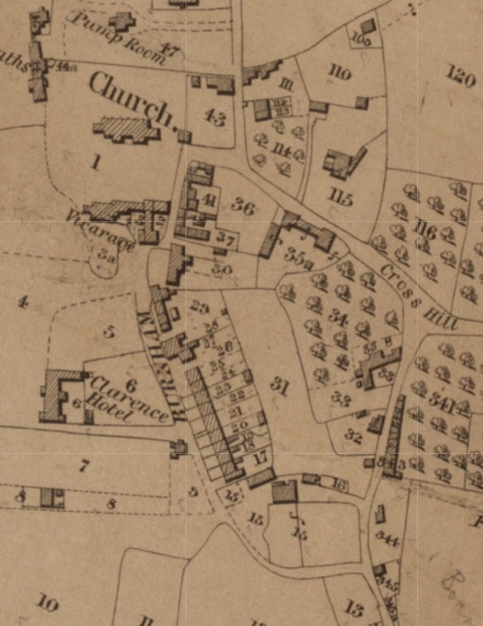
There is a record, noted by Sam Nash, of a payment of £2 10s 7½d to John Buncombe, Parish Clerk, in 1806 for education of poor children. It is not clear from this whether he was responsible for directly providing the education or merely organising it, however he did reside at Homebush which is believed to have had a schoolroom adjoining. This may be what became Burnham’s first ‘National School’ after education legislation of 1811.
In the photo below (?1950s) can be seen old buildings between Homebush and the Church Hall. A plan of 1852 confirms this to have been a school. The building, known as ‘Church House’ at the time, was finally demolished in 1962 as reported in the Burnham gazette of 31st may of that year. During the demolition process workmen discovered a thatched roof underneath the roof tiles, which was believed to be the original roof of the building.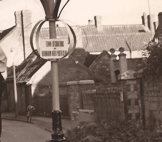
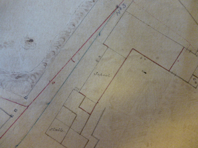
It is thought that Homebush was also at some time the home of Richard Locke. Sam Nash’s notes contain anecdotal evidence that what became the school room may have been built by Locke as a meeting place for the Burnham (Friendly) Society.
The following may illuminate some of the history of this old part of Burnham.
PARLIAMENT ROW / ‘BUG ROW’
It remains a puzzle exactly where this location was, though it seems, from the little we do know, that it was somewhere in the area between the north end of Victoria St and what is now Manor Road (previously Cross Hill). The only mentions we have found under either name are in the 1849 Report to The General Board of Health about sanitation issues in the town, and a report in the Burnham Gazette (18/02/1874) stating that the Board of Health took a Miss Dodd, the owner of Bug Row , to task over its condition and instructed her “as to putting up some shutting [shuttering?] and white liming the whole of the same”. The 1871 census shows Eliza Dodd as resident in Victoria St. The evidence seems to indicate that it was one of the poorest areas of the town. She lived with he unmarried sister, Elizabeth, born in 1793 and is described as “House Proprietor”. Eliza was born in 1798 and is similarly described as “Landed Proprietor”
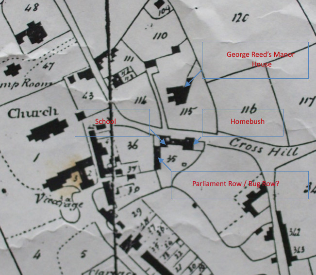
The evidence given to the Board of General Health by Joel Norris, about poor and unsanitary drainage, makes interesting reading but is somewhat confusing in its geography. It certainly involves Cross Hill, Victoria St, the parish school (probably next to Homebush) and the area in between. The possible conclusions are either that Bug Row consisted of properties in this area and since demolished (see map below) or that it was what we now know as Victoria Cottages (off Victoria St opposite the Old Vicarage). The name ‘Bug Row’ may have been a local nickname, one might speculate that it was to do with the insanitary condition of the properties, however this would not have been very different from many other properties in the town at the time. An earlier meaning of ‘bug’ is from the Old English for demon or hobgoblin!
Joel Norris is identified in the 1866 Kelly’s Directory as a grocer, linen draper and general outfitter. The 1871 census describes him as 61, retired and living in Oxford St near to Gas St, i.e. the gas works entrance. His evidence focuses on the sewage filled ditch which runs by the front of his property but also passes George Reed’s gate (entrance to Manor Gardens). It is not clear where his property is but is seems that it may be either his house or his shop (or both combined). If it is a shop it would most likely have been in Victoria St.
THE AREA IN LATER TIMES
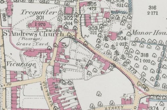
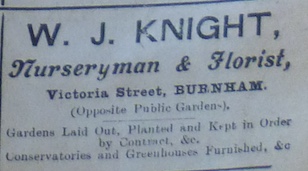
From the map above it can be seen that one of the possible candidates for ‘Parliament Row’ has been mostly demolished by the mid 19th century. On this map the area between Homebush and Victoria St appears to be formally laid out in some way and includes a small structure shaded as a glasshouse. One may wonder whether this represents Knight’s plant nursery. The advert below (date unknown) describes it as being in Victoria St but also opposite the ‘Public Gardens’ (Manor Gardens) which makes this plot a likely location.
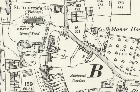
1894-1903 os map.However, the map above does not show any pathways on the plot, this may indicate a change of usage or a change in the level of map detail. The Manor Gardens did not open to the public until 1905, so whether or not the nursery occupied the land earlier, it was clearly in existence beyond the date of the 1894-1903 map.
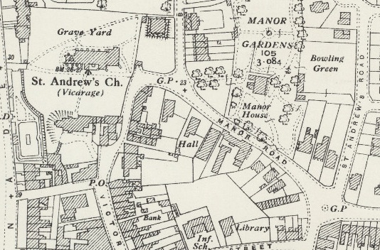
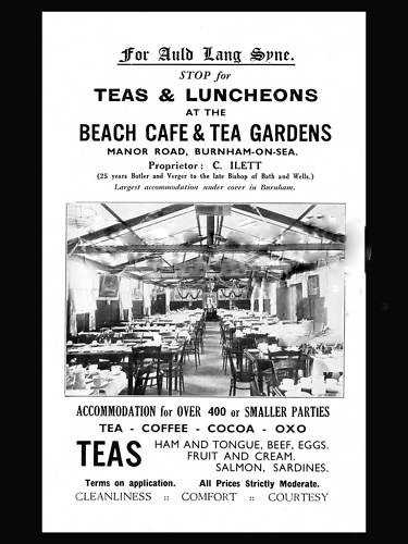
The exact location of the Beach Cafe is not proven though in notes written in 1987 Mervyn Temlett recalled that it was next to the Church Hall (possibly the building above the word Hall in the map above?). The date of the advert above is not known but the picture and menu could place it anywhere between the 1910’s & 1950’s
The proprietor Mr C. Illett is recorded in the 1939 register as living at Homebush, age 73, profession caterer. There were 2 others living with him at this address Edmund Randall (48) and Eleanor Randall (46) both assistant caterers living at his address. These two may have been his daughter and her husband. This does not prove that the cafe was still functioning at this point (he may have still been in catering in some form). However there s a record in the 1935 Kelly’s Trade Directory of “Islett & Gilbey, refrshment. rms. Manor Rd.” There is no listing in the 1929 directory so that safely places the cafe’s operations between 1929 and 1939. It remains unclear which premises it occupied.
In the 1911 census Ilett is listed as working as a butler at The Palace, Wells. where one of his under servants was an Eleanor James. (the same Eleanor as was with him at Homebush perhaps?) . He died in 1946 and is buried in Burnham Cemetery.
Research by Alan Wheway, Des Parsons & Francis Farr-Cox.
